
ExpeditionClimb
Mont Ventoux · 6 June 2026 · Christophe
The Triple Ascent — Ventoux in a day
Provence · Road · 135 km · 4 800 m · For the slightly unhinged
Read →7 min read
The lavender road
26.2 km
Distance
1,211 m
Elevation
1h30
Duration
2 ravitos
Ravitos
There is a version of Ventoux that doesn't announce itself as a war. The Bédoin road is the reference ascent — relentless forest, exposed limestone, Simpson's memorial, the mythology of the Tour pressed into every kilometre. The Sault road is something else entirely. It is the same summit, the same white ridge, the same wind at the top — but the journey there begins in lavender fields and unfolds gradually, like a long Sunday rather than an appointment with suffering.
This is Ventoux for riders who want to arrive having enjoyed the climb, not survived it. That is not a lesser achievement. It is a different one.
Gentle · 3–4% · Open plateau
The road leaves Sault across the eastern plateau, 765 metres above sea level, through landscape that in July turns an almost unreasonable shade of purple. This is the Sault that postcards are made of — rows of lavender running to the horizon, the white bulk of Ventoux visible ahead the entire time, growing slowly rather than looming.
The gradient here rarely exceeds 4%. This is not a warm-up in the conventional sense — it's riding. Conversation is possible. Looking around is not a distraction from survival. Treat these nine kilometres as the reward they are, because the character of the ride does change later.
The light on the Sault plateau in early morning has a particular quality — flat, golden, and briefly cool before the Provençal heat arrives. If there is one reason to start early, it's this hour.
Steady · 5–6% · Forest and open ground alternating
Past the lavender, the road begins to commit. The gradient settles into a steady 5–6%, rolling through alternating sections of forest and open plateau. This is the section where the ride quietly becomes a climb — not dramatically, but the legs notice the cumulative effect of kilometres that never quite go flat.
The road threads near the Col de Murs junction before continuing its long traverse toward the mountain's eastern flank. This stretch has a rhythm to it: pine shade, then open ground, then shade again. It is the longest section of the route and the one where pacing actually matters — not because any single ramp is hard, but because twelve kilometres at 5–6% adds up in a way that the first nine kilometres did not.
Exposed · 7.6% avg · The lunar section
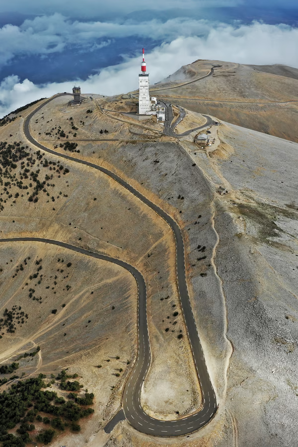
At Chalet Reynard (1,440m), the Sault road meets the Bédoin ascent, and from here the final six kilometres are identical regardless of which side you climbed. The trees end. The limestone begins. The full scale of Ventoux becomes visible for the first time — the summit observatory directly ahead, 472 metres above, across terrain that looks like nothing else in Provence.
This is the section every approach shares, and it doesn't soften for having arrived gently. The average gradient is 7.6%, the exposure is total, and the wind — present or not on the plateau below — meets you here with nothing to slow it down. Tom Simpson's memorial sits at km 20 of the Bédoin numbering, roughly 1.5 km below the summit; worth a moment regardless of which road brought you here.
The transition at Chalet Reynard is abrupt in a way that's hard to anticipate even when you know it's coming. One pedal stroke you're in pine forest. The next, you're on white rock under open sky, and the mountain shows you, finally, what all the mythology is about.
The final kilometre kicks to around 10% before the road rounds the last bend onto the summit plateau at 1,912 metres.
Meteorological station, TV antenna, a souvenir shop, and — depending on time of day — serious wind. Views are exceptional in clear conditions and absent in cloud. Expect a temperature drop of 12–15°C from Sault to the summit on a typical day; pack a light windproof regardless of season, because the exposed section above Chalet Reynard offers no protection either way.
The descent retraces the route — or, if logistics allow, descend via Bédoin or Malaucène for a different return and arrange transport back to Sault.
26.2 km
Distance
1,211 m
Elevation
—
Average gradient
1,891 m
Summit altitude
Before you go
From the journal
Mont Ventoux · 6 June 2026 · Christophe
Provence · Road · 135 km · 4 800 m · For the slightly unhinged
Get the Ravito guide in your inbox.
No noise. Unsubscribe anytime.