CyclingClimb
Nice · 1 June 2026 · Marvin
The 5 Climbs Every Cyclist Should Ride from Nice
Read →5 min read

Two cols above Nice in a single loop — the elegant Col de Braus and the legendary Col de Turini, 1,604 metres, home of the Monte Carlo Rally. Sospel in between. 112 km, 2,497 metres of climbing.
112 km
Distance
2,497 m
Elevation
5h50
Duration
3 ravitos
Ravitos
Nice has the sea, the promenade, the light that painters spent the twentieth century trying to describe. It also has the mountains directly behind it — and the roads into those mountains are why this is one of the great cycling territories in Europe.
This loop takes two of them in a single day.
The warm-up is the Col de Nice — a gentle first climb that lifts you above the city and sets the gradient before the day's main climbs begin. Useful. The legs need it. The Col de Braus comes next, rising through a series of famous switchbacks above the village of L'Escarène, gaining 900 metres in a steady, elegant ascent that doesn't announce its difficulty until the final kilometres. The road was built in the 19th century to connect the coast to the hinterland, and it still feels designed rather than merely constructed — the corners well-judged, the gradient honest, the views over the Roya valley appearing in sequence as the altitude builds.
The descent from Braus is fast and technically demanding. It drops into the valley of the Bévéra, and the valley leads to Sospel.
Sospel is a medieval town built on a bend in the river, its old bridge and its Baroque cathedral having survived the 20th century in better condition than the century deserved. It is also the last proper stop before the day's defining climb. Fill the bottles. The café tables on the main square are a reasonable place to do it. The Col de Turini starts effectively from the edge of town, and it is 24 kilometres long.
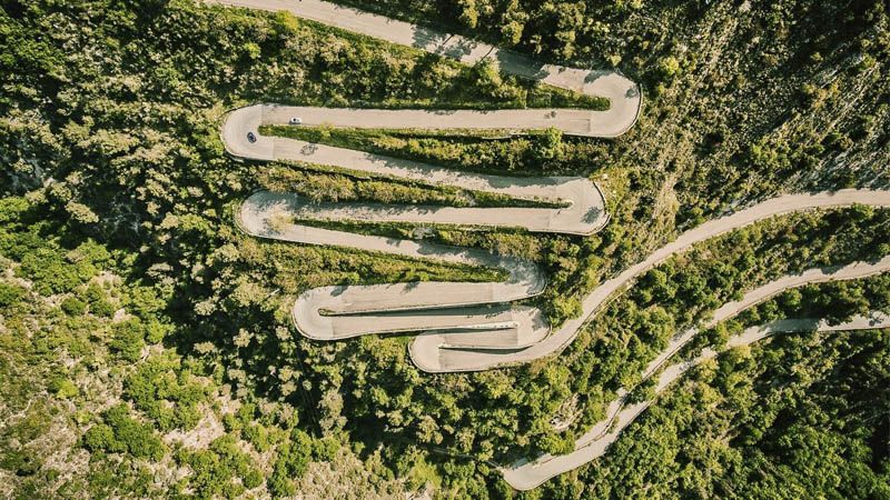
The Col de Turini begins in the Gorges du Piaon — a narrow limestone gorge where the road is carved into the cliff above the river, the gradient reasonable in these first kilometres, the scenery doing the work. After the gorge, a series of tighter hairpins leads to the Chapelle Notre-Dame de la Ménour, perched on a rocky outcrop at 780 metres, a pilgrimage chapel that has been watching over the valley since the 15th century and which marks the end of the climb's first half.
Moulinet, at the midpoint, is a brief breath. A small mountain village where the gradient softens for a kilometre or two before the road reasserts itself. The second half of the Turini, from Moulinet to the summit, is where the col earns its reputation: sustained 7–8% through a dense conifer forest, the sky visible in patches above the canopy, the surface perfect. This is the road that the Monte Carlo Rally uses for its legendary night stage — the same hairpins, the same limestone, the same sequence of corners that drivers have been treating as a stage finale since the 1960s. On a bicycle at your own pace, with no co-driver and no pace notes, it is simply a very good climb.
At 1,604 metres, the summit collects roads from four directions. The Hôtel des Trois Vallées at the top has been here longer than most of the rally's history, its walls covered in trophies, photographs, and memories of decades of motorsport that passed by outside. Worth a stop. The tarte aux myrtilles is a local institution.
The return to Nice is 50 kilometres of descent — fast, flowing, the Alpes-Maritimes hinterland opening progressively into the coastal plain, the city appearing below as the altitude drops. A long way to come down from 1,604 metres. It takes a while. That is the correct amount of time for a descent that the climb took all afternoon to earn.
112 km · +2,497 m · Road
| Segment | Notes |
|---|---|
| Nice → Col de Nice | Warm-up climb, ~5 km, exits the city |
| Col de Nice → Col de Braus (from L'Escarène) | 900 m gain, famous switchbacks, views over Roya valley |
| Col de Braus → Sospel | Technical descent into the Bévéra valley |
| Sospel | Last stop — water, food, café before the Turini |
| Gorges du Piaon (km ~0–10 of Turini) | Narrow gorge, cliff road, gradient builds progressively |
| Chapelle Notre-Dame de la Ménour (km ~10) | Rocky outcrop, pilgrimage chapel, end of first section |
| Moulinet (km ~12) | Mid-climb village, brief respite |
| Moulinet → Col de Turini (km ~12–24) | 7–8% sustained, conifer forest, Monte Carlo Rally road |
| Col de Turini summit (1,604 m) | Hôtel des Trois Vallées, café, tartes aux myrtilles |
| Summit → Nice | ~50 km descent to the coast |
112 km
Distance
2,497 m
Elevation
6%
Average gradient
1,624 m
Summit altitude
Before you go
From the journal
Nice · 1 June 2026 · Marvin
Get the Ravito guide in your inbox.
No noise. Unsubscribe anytime.