Via del Sale
Tende · Casterino · Refuge Don Barbera · Passo di Tanarello
98.7 km
Distance
2,771 m
Elevation
5h30
Duration
1 ravito
Ravitos
The Via del Sale — the Salt Road, depending on which side of the border you call home — is not a ride you slot into a normal week. It requires planning, commitment, and either a car to Tende or a ticket on the Train des Merveilles. It asks something of you before you even clip in. That is exactly the point.
This is one of the highest unpaved routes near Nice, a ridge traverse along an ancient trade route that connected the Ligurian coast to the Piedmontese plains long before tarmac existed. What remains of its construction is not ruins but a road — a proper double-track path that happens to run at altitude, above the treeline, where the only things on the horizon are summits.
Km 0 – 22 · Tende / Saint-Dalmas to Casterino — the approach
Paved · 13 km mountain road · Setting the scene
There are two ways to begin. The direct option follows the old Franco-Italian border road from Tende, its hairpins threading up past abandoned military casernes and old frontier posts. It is steep, quiet, and immediately committed.
The longer start begins at the abandoned Mussolini-era station at Saint-Dalmas-de-Tende, a building that still has the scale of ambition without the purpose. From here, a 13 km mountain road climbs to the hamlet of Casterino — beautiful riding through pine forest, with enough gradient to inform the legs of what is coming.
Either way, Tende is the psychological reset. Look up: you are surrounded by summits on all sides. The alpine world here bears no resemblance to the Côte d'Azur an hour below.
There is a specific moment on the approach to Casterino when the valley walls close in and the sky becomes a corridor. You understand then that this ride is not about kilometres. It is about altitude, and what altitude does to the sense of scale.
Km 22 – 45 · Casterino to Col de Tende — the traverse begins
Gravel · Above treeline · Panoramic
From Casterino, the route climbs the eastern flank of the valley, pushing above the treeline toward the Baisse de Peïrefique. Above this pass, the character of the ride changes completely. The gradient eases and the track follows the curve of the mountain — relatively flat, entirely exposed, with a sustained view over the Col de Tende and the ridgelines beyond.
This section is the route's breathing space. Use it to eat, take in the scale, and prepare mentally for what follows from the Col eastward.
Km 45 – 68 · Col de Tende to Refuge Don Barbera — the ridge
Technical gravel · Exposed · Physically demanding
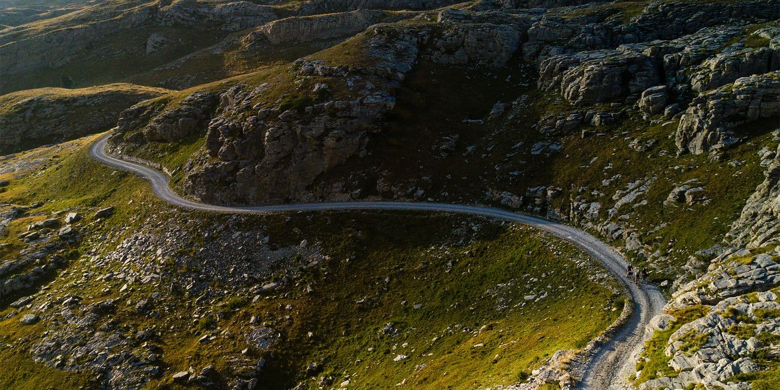
East of the Col de Tende is where the Via del Sale announces itself. The track commits to the ridgeline and stays there — a switchback sequence of ascents and short descents, in and out of the mountain's contours, with the summit line always close overhead.
The defining moment comes when the path hugs a cliff edge pointing northeast toward Turin before reversing sharply toward the Mediterranean. It is the kind of panorama that appears unreasonable — two coastlines in the same frame, the Alps folding down to the sea in both directions.
Those who have ridden the Torino-Nice Rally will remember this section with particular feeling. It is the kind of terrain that makes time unreliable — an hour passes like twenty minutes, and twenty minutes can feel like an hour.
Rifle Don Barbera sits 20 km from the Col de Tende, recessed into the hillside and easily missed. A refuge in the genuine sense: mountain food, a dormitory, and a view that still surprises in the morning. If the legs are speaking loudly and the afternoon is late, stay. The temptation is legitimate.
Km 68 – 82 · Refuge Don Barbera to Passo di Tanarello — the final ascent
Steep · Rocky · Worth every metre
From the Refuge, the route climbs to the Cime de Pertégue — a high point that earns its name. Below, pine forest hides some of the best mountain huts in the Alps-Maritimes, the kind that look pulled from a Scandinavian design book but are very much Italian.
The final climb to Passo di Tanarello is the hardest section of the ride. It is steep, the surface is rough in places, and there is no shelter. At the pass, the accordion of summits folding toward the coast comes into full view — a line of peaks stacked southwest all the way to the sea. It is the last photograph you take before the descent takes over.
Km 82 – 98 · Passo di Tanarello to La Brigue — the descent
Long · Technical · Forearm warning
The descent to La Brigue is substantial — 16 km of rough gravel requiring proper bike control, confidence in the brakes, and forearms willing to stay honest. The surface alternates between smooth track and loose stone. Speed is possible but demands attention.
Four hours on rough terrain is worth six on smooth. The Via del Sale is not a place for statistics. It is an experience that stays.
La Brigue itself is a medieval village at the valley floor — stone, quiet, unhurried. A good place to sit down.
Ravito spots
Tende (km 0) — stock up here Last reliable supply point before the ridge. Fill bidons, carry food for the full day. There are no cafés above the treeline.
Casterino (km 22) — last café Small hamlet with a bar-restaurant. The last opportunity for coffee and a proper sit-down before the gravel begins. Do not skip it.
Rifugio Don Barbera (km 68) — mountain refuge Food, drinks, accommodation. Italian mountain cooking. If you're doing this as a multi-day ride, this is the overnight. Even if you're not, stop for something warm.
La Brigue (km 98) — finish line Several bars and a restaurant in the village. You will have earned whatever you order.
98.7 km
Distance
2,771 m
Elevation
—
Average gradient
2,222 m
Summit altitude
Before you go
- BikeGravel bike required; 38mm+ tyres strongly recommended
- Key climbBaisse de Peïrefique and Passo di Tanarello, sustained above 1,800m
- SurfaceMixed: mountain road to Casterino, double-track gravel above
- WaterCarry minimum 2L; mountain springs on route but not guaranteed