The Girona Gravel 200 — Three Landscapes, One Long Day
Two hundred kilometres of gravel north, east, and south of Girona — through the Pla de l'Estany, across the Empordà plains, and back through the Gavarres. Three distinct landscapes, 84% unpaved, and the best way to understand what this corner of Catalonia actually is.
201 km
Distance
2,912 m
Elevation
10h10
Duration
2 ravitos
Ravitos
The best way to understand the geography around Girona is to ride through all of it in a single day. Two hundred kilometres is what that takes.
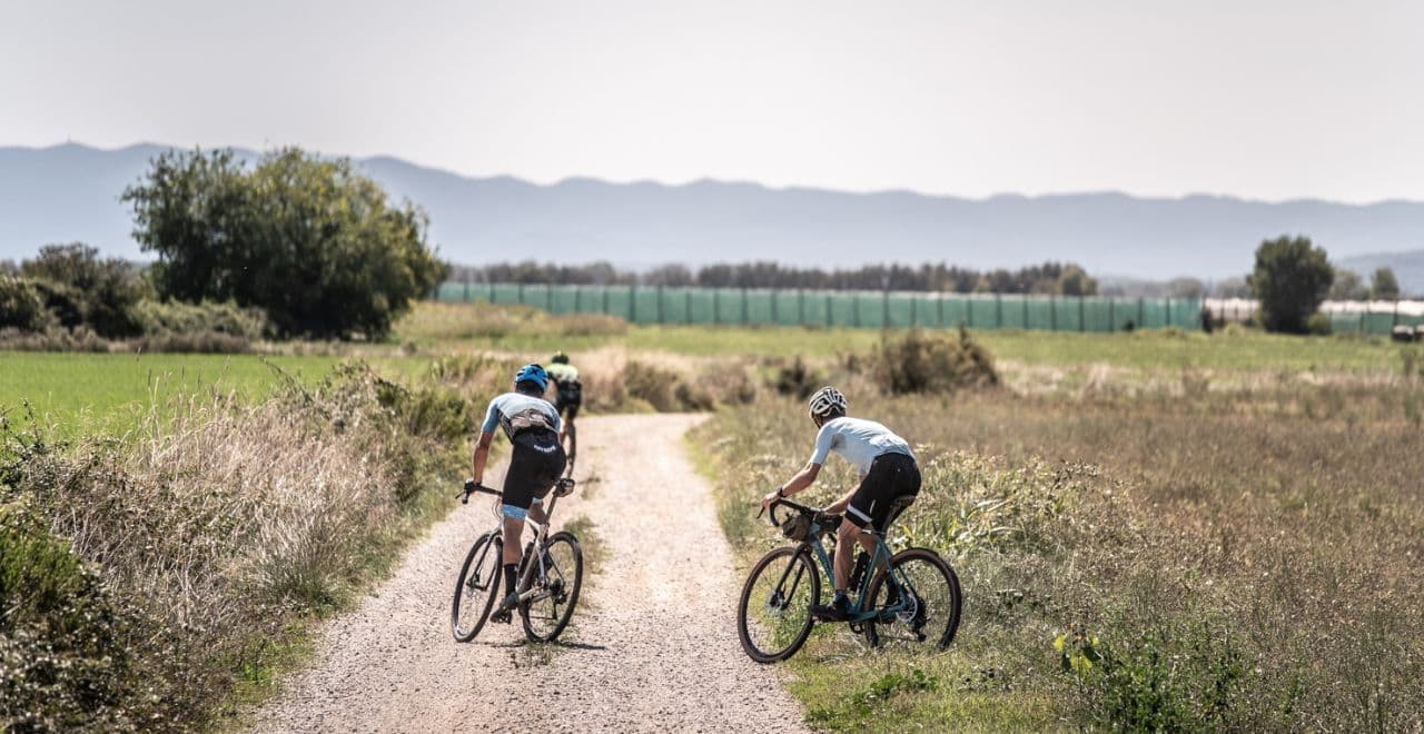
The route begins with a short paved climb out of the old city — enough to clear the last buildings and place you above the roofline before the road dissolves into gravel and drops toward the Ter. The river appears briefly at the bottom, wide and unhurried, and then the route turns north, which is the direction the 100 does not go.
The Pla de l'Estany is the first landscape. The name means "plain of the lake", and both words are accurate: a flat basin of agricultural land dotted with rivers and wetlands, sitting between the first ridges of the Pyrenean foothills and the Empordà plain. The gravel here is the kind that rewards momentum — compacted earth between fields of wheat and fruit trees, the gradient almost absent, the tracks wide enough to carry real speed. Banyoles sits at the centre, its lake visible through the willows on the south shore, the water a specific shade of blue-green that comes from the limestone aquifer feeding it from below rather than from the sky above. It is the largest natural lake in Catalonia, and it looks it.
North of Banyoles, the terrain shifts. The Pla de l'Estany closes into something more enclosed — narrower tracks, denser vegetation, the occasional rocky section announcing that the flat country is not the whole story. This transition is gradual enough that you miss the moment it happens, which is typical of this region: the landscapes don't announce themselves, they accumulate.
Then east, and the Empordà opens up. This is the largest and most varied section of the route — wide gravel farm tracks rolling through olive groves and vineyards, stone farmhouses set back from the road with no affectation, medieval villages appearing on ridgelines and disappearing again. To the southeast, the Castell de Montgrí is visible for much of this section: a massive unfinished fortress on a limestone ridge above the coastal plain, built in the thirteenth century as a deterrent to Mediterranean pirates, the interior never completed. It has looked exactly the same for seven hundred years. The resemblance to Tuscany that every cyclist mentions is not wrong — the same agricultural light, the same economy of ornament — but the Empordà has its own character, wilder and more exposed, the wind off the sea reaching further inland than you expect.
Cassà de la Selva, south of Girona at roughly kilometre 125, is the last reliable stop before the return leg. Fill the bottles here. The Gavarres are next.
Les Gavarres are what the end of the day looks like. A compact massif of cork oak and pine between the Empordà plain and the coast, crossed by old stone paths and gravel tracks that climb in short, punchy bursts and descend in technical sequences that require full attention on tired legs. The surface loosens as altitude rises. The tracks narrow. The views that appear above the canopy — across the Empordà toward the sea, the Montgri visible to the east, the Pyrenees to the north — arrive without warning and disappear just as quickly. This is the section where the effort of the day becomes concrete: not a single brutal climb but an accumulation of short climbs on legs that have been working for six or seven hours. The Gavarres section is also the most beautiful part of the route, which is a useful coincidence.
The descent from Les Gavarres back into the Ter valley is fast and flowing. The greenway along the river delivers you back into Girona, the medieval walls of the old city appearing ahead, the light by now entirely different from what it was at the start of the morning.
Two hundred kilometres through three distinct landscapes, 84% of them unpaved, each section different enough from the last to feel like a separate ride, all of them within an hour of a city that has been shaped by cycling culture for long enough to do it properly. The Traka 200 uses this itinerary as its flagship route each May. The course is worth riding any time.
Route
202 km · +2,650 m · 84% unpaved · Gravel
| Segment | Notes |
|---|---|
| Girona → Ter river | Short paved climb, gravel descent to the river |
| Ter → Pla de l'Estany / Banyoles (km ~15–60) | Flat farm tracks north, Banyoles lake, varied surface |
| Pla de l'Estany → Empordà interior (km ~60–100) | Terrain tightening, narrower tracks, transition zone |
| Empordà plains (km ~100–125) | Wide fast gravel, Castell de Montgrí visible, medieval villages |
| Cassà de la Selva (km ~125) | Last reliable water and food stop before the Gavarres |
| Les Gavarres (km ~125–185) | Cork oak forest, punchy climbs, technical descents |
| Gavarres → Girona via Ter valley | Descent and return on the Ter river greenway |
Route follows the same itinerary used by the Traka 200, Girona's annual gravel event held each May.
201 km
Distance
2,912 m
Elevation
—
Average gradient
464 m
Summit altitude
Traka 100
97 km · 1435 m
https://ravito.club/places/traka-100
Before you go
- Tyre choice84% unpaved across three very different surfaces. Hard-packed Empordà tracks, loose limestone climbs in the Gavarres, narrow cork oak singletrack. A 40–42mm minimum; many riders on this itinerary run 45mm or wider for the Gavarres section. Nothing narrower than 38mm makes sense.
- Cassà de la SelvaThe Gavarres section has no reliable infrastructure. Treat Cassà as a checkpoint regardless of how you feel — fill everything and eat something substantial before the final 75 kilometres.
- Three landscapesThe Pla de l'Estany rewards momentum — ride it efficiently. The Empordà middle section is where you eat and drink consistently even when the terrain feels easy. The Gavarres at the end is where everything you've done before shows up in your legs. Manage the first two sections with the third in mind.
- The windThe Empordà plain is exposed to two dominant winds: the Tramuntane from the north, and the Garbí from the sea in the afternoon. Both can be significant factors on the open farm tracks of the central section. Check the forecast the evening before — a tailwind north becomes a headwind south, and vice versa.
- Start earlyA 7am departure from Girona gives a generous buffer and puts you in the Empordà in the best morning light. The final kilometres back through the Ter valley are better ridden in the late afternoon than in darkness.